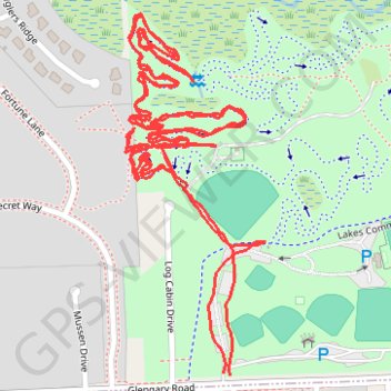
Hickory Glen MTB Trail: The Original Mile
- Distance: 2.7 mi
- Elevation gain: 49 ft
- Maximum elevation: 938 ft
- Elevation loss: 52 ft
- Minimum elevation: 909 ft
- Moving time: 1 h 4 m
- Moving speed: 2.5 mph
- Maximum speed: 4.0 mph
- Total time: 1 h 8 m
- Global speed: 2.3 mph
Interactive trail map
Trail profile
- Distance: 2.7 mi
- Elevation gain: 49 ft
- Maximum elevation: 938 ft
- Elevation loss: 52 ft
- Minimum elevation: 909 ft
- Moving time: 1 h 4 m
- Moving speed: 2.5 mph
- Maximum speed: 4.0 mph
- Total time: 1 h 8 m
- Global speed: 2.3 mph
About this trail
Name: Hickory Glen MTB Trail: The Original Mile trail, distance, elevation, map, profile, GPS track
Coordinates: 42.56224 -83.48944 42.56754 -83.48665
Topography: Oakland County topographic map, elevation, terrain
Other hiking, mountain biking, running and outdoor activity trails
Click on a trail to view its statistics, map and profile.
Hickory Glen MTB Trail: Spin Cycle
United States > Michigan > Oakland County > Commerce Charter Township > Wolverine Lake
Distance: 3.7 mi • Elevation gain: 98 ft • Maximum elevation: 935 ft
Hickory Glen MTB Trail: Trenches
United States > Michigan > Oakland County > Commerce Charter Township > Wolverine Lake
Distance: 2.0 mi • Elevation gain: 26 ft • Maximum elevation: 942 ft