Thank you for supporting this site ❤️
Make a donation
Make a donation
Gear up for your next adventure:
As an Amazon Associate, this site earns from qualifying purchases at no extra cost to you.
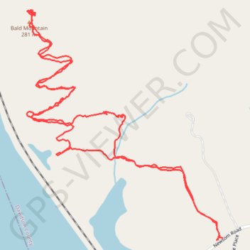
Bald Mountain Trail
- Distance: 2.8 mi
- Elevation gain: 390 ft
- Maximum elevation: 938 ft
- Elevation loss: 390 ft
- Minimum elevation: 591 ft
- Moving time: 1 h 33 m
- Moving speed: 1.8 mph
- Maximum speed: 4.5 mph
- Total time: 2 h 58 m
- Global speed: 0.9 mph
Interactive trail map
Thank you for supporting this site ❤️
Make a donation
Make a donation
Gear up for your next adventure:
As an Amazon Associate, this site earns from qualifying purchases at no extra cost to you.
Trail profile
- Distance: 2.8 mi
- Elevation gain: 390 ft
- Maximum elevation: 938 ft
- Elevation loss: 390 ft
- Minimum elevation: 591 ft
- Moving time: 1 h 33 m
- Moving speed: 1.8 mph
- Maximum speed: 4.5 mph
- Total time: 2 h 58 m
- Global speed: 0.9 mph
Thank you for supporting this site ❤️
Make a donation
Make a donation
Gear up for your next adventure:
As an Amazon Associate, this site earns from qualifying purchases at no extra cost to you.
About this trail
Name: Bald Mountain Trail trail, distance, elevation, map, profile, GPS track
End: Newsom Road, Newsom, Davidson County, North Carolina, United States (35.53918 -80.18865)
Coordinates: 35.53918 -80.19625 35.54665 -80.18845
Topography: Davidson County topographic map, elevation, terrain
Thank you for supporting this site ❤️
Make a donation
Make a donation
Gear up for your next adventure:
As an Amazon Associate, this site earns from qualifying purchases at no extra cost to you.