Make a donation
Gear up for your next adventure:
As an Amazon Associate, this site earns from qualifying purchases at no extra cost to you.
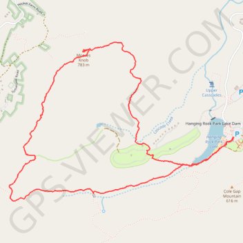
Moores Wall Loop Trail
Hanging Rock
- Distance: 4.7 mi
- Elevation gain: 866 ft
- Maximum elevation: 2,490 ft
- Elevation loss: 869 ft
- Minimum elevation: 1,706 ft
- Moving time: 2 h 19 m
- Moving speed: 2.0 mph
- Maximum speed: 7.3 mph
- Total time: 3 h 7 m
- Global speed: 1.5 mph
Interactive trail map
Make a donation
Gear up for your next adventure:
As an Amazon Associate, this site earns from qualifying purchases at no extra cost to you.
Trail profile
- Distance: 4.7 mi
- Elevation gain: 866 ft
- Maximum elevation: 2,490 ft
- Elevation loss: 869 ft
- Minimum elevation: 1,706 ft
- Moving time: 2 h 19 m
- Moving speed: 2.0 mph
- Maximum speed: 7.3 mph
- Total time: 3 h 7 m
- Global speed: 1.5 mph
Make a donation
Gear up for your next adventure:
As an Amazon Associate, this site earns from qualifying purchases at no extra cost to you.
About this trail
Name: Moores Wall Loop Trail trail, distance, elevation, map, profile, GPS track
Start: Hanging Rock Connector Trail, Stokes County, North Carolina, United States (36.39081 -80.26678)
End: Hanging Rock Connector Trail, Stokes County, North Carolina, United States (36.39082 -80.26685)
Coordinates: 36.38530 -80.29091 36.39901 -80.26678
Topography: Stokes County topographic map, elevation, terrain
Make a donation
Gear up for your next adventure:
As an Amazon Associate, this site earns from qualifying purchases at no extra cost to you.
Other hiking, mountain biking, running and outdoor activity trails
Click on a trail to view its statistics, map and profile.
Hanging Rock - Wolf Rock Trail, Cole Gap Mountain, Hanging Rock Park Lake, Upper Cascades
United States > North Carolina > Stokes County
Distance: 3.8 mi • Elevation gain: 548 ft • Maximum elevation: 1,991 ft
Hanging Rock - Cooks Wall Mountain
United States > North Carolina > Stokes County
Distance: 4.0 mi • Elevation gain: 696 ft • Maximum elevation: 2,300 ft
Hanging Rock State Park Waterfalls
United States > North Carolina > Stokes County
Distance: 2.3 mi • Elevation gain: 443 ft • Maximum elevation: 1,699 ft
Hanging Rock - Moores Knob
United States > North Carolina > Stokes County
Distance: 4.2 mi • Elevation gain: 873 ft • Maximum elevation: 2,487 ft
Make a donation
Gear up for your next adventure:
As an Amazon Associate, this site earns from qualifying purchases at no extra cost to you.