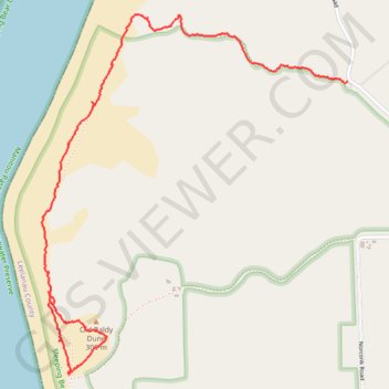
Sleeping bear hike
- Distance: 2.5 mi
- Elevation gain: 502 ft
- Maximum elevation: 988 ft
- Elevation loss: 472 ft
- Minimum elevation: 797 ft
- Moving time: 1 h 20 m
- Moving speed: 1.9 mph
- Maximum speed: 8.2 mph
- Total time: 1 h 55 m
- Global speed: 1.3 mph
Interactive trail map
Trail profile
- Distance: 2.5 mi
- Elevation gain: 502 ft
- Maximum elevation: 988 ft
- Elevation loss: 472 ft
- Minimum elevation: 797 ft
- Moving time: 1 h 20 m
- Moving speed: 1.9 mph
- Maximum speed: 8.2 mph
- Total time: 1 h 55 m
- Global speed: 1.3 mph
About this trail
Name: Sleeping bear hike trail, distance, elevation, map, profile, GPS track
Start: No Name Trail, Empire Township, Leelanau County, Michigan, 49630, United States (44.79068 -86.07592)
Coordinates: 44.78723 -86.07628 44.80209 -86.05854
Topography: Leelanau County topographic map, elevation, terrain
Other hiking, mountain biking, running and outdoor activity trails
Click on a trail to view its statistics, map and profile.
Empire Bluff Trail in Sleeping Bear Dunes National Lakeshore
United States > Michigan > Leelanau County > Empire
The Empire Bluff Trail offers a rewarding hike through a beech-maple forest, leading to a spectacular viewpoint overlooking Lake Michigan. As you progress along the trail, you’ll experience diverse natural scenery, from shady wooded areas to scenic overlooks with views of the sweeping dunes, the…
Distance: 1.7 mi • Elevation gain: 266 ft • Maximum elevation: 984 ft