Make a donation
Gear up for your next adventure:
As an Amazon Associate, this site earns from qualifying purchases at no extra cost to you.
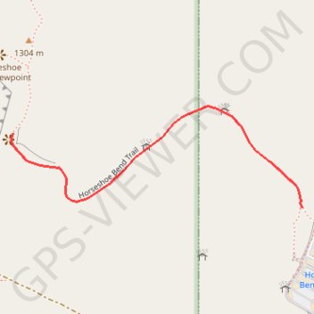
Horseshoe Bend Viewpoint (Colorado River)
Interactive trail map
Make a donation
Gear up for your next adventure:
As an Amazon Associate, this site earns from qualifying purchases at no extra cost to you.
Trail profile
- Distance: 0.6 mi
- Elevation gain: 0 ft
- Maximum elevation: 4,327 ft
- Elevation loss: 364 ft
- Minimum elevation: 3,960 ft
Make a donation
Gear up for your next adventure:
As an Amazon Associate, this site earns from qualifying purchases at no extra cost to you.
About this trail
Name: Horseshoe Bend Viewpoint (Colorado River) trail, distance, elevation, map, profile, GPS track
Start: Horseshoe Bend Trail, Page, Coconino County, Arizona, United States (36.87777 -111.50320)
End: Horseshoe Bend Trail, Page, Coconino County, Arizona, United States (36.87928 -111.51053)
Coordinates: 36.87777 -111.51057 36.87983 -111.50320
Topography: Page topographic map, elevation, terrain
Make a donation
Gear up for your next adventure:
As an Amazon Associate, this site earns from qualifying purchases at no extra cost to you.
Other hiking, mountain biking, running and outdoor activity trails
Click on a trail to view its statistics, map and profile.