Make a donation
Gear up for your next adventure:
As an Amazon Associate, this site earns from qualifying purchases at no extra cost to you.
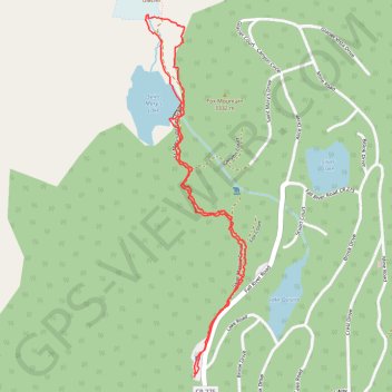
Saint Mary's Lake and Saint Mary's Glacier in Arapaho National Forest
The hike to Saint Mary's Glacier is a fantastic choice for anyone looking to enjoy some stunning mountain views without a super long trek. You’ll find a lovely alpine lake early on, and if you're up for it, heading a bit higher offers even better scenery. Plus, spotting moose along the way adds a nice touch to this enjoyable, rocky trail. #Hiking #Mountain #Lake #Forest #Nature
- Distance: 2.0 mi
- Elevation gain: 522 ft
- Maximum elevation: 10,863 ft
- Elevation loss: 525 ft
- Minimum elevation: 10,338 ft
- Moving time: 1 h 19 m
- Moving speed: 1.5 mph
- Maximum speed: 3.3 mph
- Total time: 1 h 43 m
- Global speed: 1.1 mph
Interactive trail map
Make a donation
Gear up for your next adventure:
As an Amazon Associate, this site earns from qualifying purchases at no extra cost to you.
Trail profile
- Distance: 2.0 mi
- Elevation gain: 522 ft
- Maximum elevation: 10,863 ft
- Elevation loss: 525 ft
- Minimum elevation: 10,338 ft
- Moving time: 1 h 19 m
- Moving speed: 1.5 mph
- Maximum speed: 3.3 mph
- Total time: 1 h 43 m
- Global speed: 1.1 mph
Make a donation
Gear up for your next adventure:
As an Amazon Associate, this site earns from qualifying purchases at no extra cost to you.
About this trail
Name: Saint Mary's Lake and Saint Mary's Glacier in Arapaho National Forest trail, distance, elevation, map, profile, GPS track
Start: Lake Road, Clear Creek County, Colorado, United States (39.82499 -105.64475)
End: Lake Road, Clear Creek County, Colorado, United States (39.82487 -105.64475)
Coordinates: 39.82487 -105.64658 39.83537 -105.64278
Topography: Clear Creek County topographic map, elevation, terrain
Make a donation
Gear up for your next adventure:
As an Amazon Associate, this site earns from qualifying purchases at no extra cost to you.
Other hiking, mountain biking, running and outdoor activity trails
Click on a trail to view its statistics, map and profile.