Thank you for supporting this site ❤️
Make a donation
Make a donation
Gear up for your next adventure:
As an Amazon Associate, this site earns from qualifying purchases at no extra cost to you.
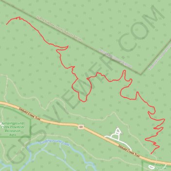
CMBA/AEP Ten Years Gone trail
- Distance: 3.2 mi
- Elevation gain: 709 ft
- Maximum elevation: 5,016 ft
- Elevation loss: 223 ft
- Minimum elevation: 4,524 ft
- Moving time: 1 h 23 m
- Moving speed: 2.3 mph
- Maximum speed: 5.0 mph
- Total time: 1 h 46 m
- Global speed: 1.8 mph
Interactive trail map
Thank you for supporting this site ❤️
Make a donation
Make a donation
Gear up for your next adventure:
As an Amazon Associate, this site earns from qualifying purchases at no extra cost to you.
Trail profile
- Distance: 3.2 mi
- Elevation gain: 709 ft
- Maximum elevation: 5,016 ft
- Elevation loss: 223 ft
- Minimum elevation: 4,524 ft
- Moving time: 1 h 23 m
- Moving speed: 2.3 mph
- Maximum speed: 5.0 mph
- Total time: 1 h 46 m
- Global speed: 1.8 mph
Thank you for supporting this site ❤️
Make a donation
Make a donation
Gear up for your next adventure:
As an Amazon Associate, this site earns from qualifying purchases at no extra cost to you.
About this trail
Name: CMBA/AEP Ten Years Gone trail trail, distance, elevation, map, profile, GPS track
Start: Ten Years Gone, Kananaskis Improvement District, Alberta, Canada (51.03806 -114.72989)
End: Ten Years Gone, Kananaskis Improvement District, Alberta, Canada (51.05087 -114.75265)
Coordinates: 51.03806 -114.75265 51.05162 -114.72774
Thank you for supporting this site ❤️
Make a donation
Make a donation
Gear up for your next adventure:
As an Amazon Associate, this site earns from qualifying purchases at no extra cost to you.