Thank you for supporting this site ❤️
Make a donation
Make a donation
Gear up for your next adventure:
As an Amazon Associate, this site earns from qualifying purchases at no extra cost to you.
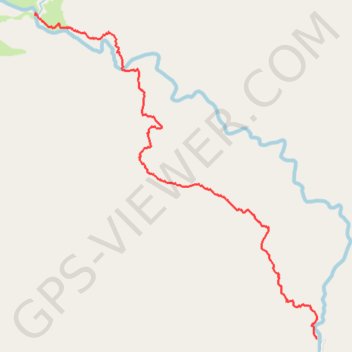
Mường Tè District Hike
- Distance: 4.7 mi
- Elevation gain: 1,368 ft
- Maximum elevation: 6,404 ft
- Elevation loss: 2,684 ft
- Minimum elevation: 4,442 ft
- Moving time: 2 h 56 m
- Moving speed: 1.6 mph
- Maximum speed: 11.9 mph
- Total time: 4 h 32 m
- Global speed: 1.0 mph
Interactive trail map
Thank you for supporting this site ❤️
Make a donation
Make a donation
Gear up for your next adventure:
As an Amazon Associate, this site earns from qualifying purchases at no extra cost to you.
Trail profile
- Distance: 4.7 mi
- Elevation gain: 1,368 ft
- Maximum elevation: 6,404 ft
- Elevation loss: 2,684 ft
- Minimum elevation: 4,442 ft
- Moving time: 2 h 56 m
- Moving speed: 1.6 mph
- Maximum speed: 11.9 mph
- Total time: 4 h 32 m
- Global speed: 1.0 mph
Thank you for supporting this site ❤️
Make a donation
Make a donation
Gear up for your next adventure:
As an Amazon Associate, this site earns from qualifying purchases at no extra cost to you.
About this trail
Name: Mường Tè District Hike trail, distance, elevation, map, profile, GPS track
Start: Pa Vệ Sử Commune, Mường Tè District, Lai Châu Province, Vietnam (22.59764 102.80980)
End: Pa Vệ Sử Commune, Mường Tè District, Lai Châu Province, Vietnam (22.56376 102.84175)
Coordinates: 22.56376 102.80979 22.59787 102.84176
Thank you for supporting this site ❤️
Make a donation
Make a donation
Gear up for your next adventure:
As an Amazon Associate, this site earns from qualifying purchases at no extra cost to you.