Make a donation
Gear up for your next adventure:
As an Amazon Associate, this site earns from qualifying purchases at no extra cost to you.
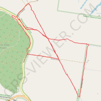
Yurol State Forest - Yurol Road Crossing
Morning Run
- Distance: 6.7 mi
- Elevation gain: 479 ft
- Maximum elevation: 427 ft
- Elevation loss: 472 ft
- Minimum elevation: 308 ft
- Moving time: 1 h 19 m
- Moving speed: 5.0 mph
- Maximum speed: 9.6 mph
- Total time: 1 h 25 m
- Global speed: 4.7 mph
Interactive trail map
Make a donation
Gear up for your next adventure:
As an Amazon Associate, this site earns from qualifying purchases at no extra cost to you.
Trail profile
- Distance: 6.7 mi
- Elevation gain: 479 ft
- Maximum elevation: 427 ft
- Elevation loss: 472 ft
- Minimum elevation: 308 ft
- Moving time: 1 h 19 m
- Moving speed: 5.0 mph
- Maximum speed: 9.6 mph
- Total time: 1 h 25 m
- Global speed: 4.7 mph
Make a donation
Gear up for your next adventure:
As an Amazon Associate, this site earns from qualifying purchases at no extra cost to you.
About this trail
Name: Yurol State Forest - Yurol Road Crossing trail, distance, elevation, map, profile, GPS track
Start: Yurol Forest Drive, Pomona, Noosa Shire, Queensland, 4568, Australia (-26.38171 152.88797)
End: Yurol Forest Drive, Pomona, Noosa Shire, Queensland, 4568, Australia (-26.38209 152.88805)
Coordinates: -26.39212 152.88411 -26.37061 152.90392
Make a donation
Gear up for your next adventure:
As an Amazon Associate, this site earns from qualifying purchases at no extra cost to you.
Other hiking, mountain biking, running and outdoor activity trails
Click on a trail to view its statistics, map and profile.
Imbil Jimna Kenilworth loop
Australia > Queensland > Tewantin
Distance: 134.2 mi • Elevation gain: 12,743 ft • Maximum elevation: 2,697 ft
Make a donation
Gear up for your next adventure:
As an Amazon Associate, this site earns from qualifying purchases at no extra cost to you.
Yurol State Forest Loop
Australia > Queensland > Cooroy
Distance: 28.0 mi • Elevation gain: 2,001 ft • Maximum elevation: 476 ft
Kandanga Wrattens Widgee Loop
Australia > Queensland > Tewantin
Distance: 136.9 mi • Elevation gain: 11,759 ft • Maximum elevation: 2,244 ft
Yurol area ride trace
Australia > Queensland > Tewantin
Distance: 42.3 mi • Elevation gain: 2,523 ft • Maximum elevation: 574 ft
Noosa Enduro MTB Course
Australia > Queensland > Tewantin
Distance: 56.9 mi • Elevation gain: 5,548 ft • Maximum elevation: 1,509 ft
Make a donation
Gear up for your next adventure:
As an Amazon Associate, this site earns from qualifying purchases at no extra cost to you.