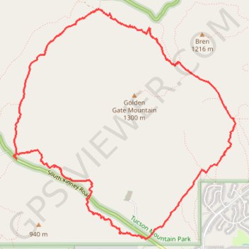
Kinney Trail and others circling Golden Gate Mountain, Tucson
Loop hike around Golden Gate Mountain via Kinney Trail, Tucson Estates Trail, Coyote Trail, Yetman Trail and Golden Gate Trail in the Tucson Mountain Park. #Hiking #Loop #Mountain #Nature
- Distance: 6.5 mi
- Elevation gain: 715 ft
- Maximum elevation: 3,202 ft
- Elevation loss: 719 ft
- Minimum elevation: 2,605 ft
- Moving time: 2 h 30 m
- Moving speed: 2.6 mph
- Maximum speed: 19.6 mph
- Total time: 2 h 45 m
- Global speed: 2.4 mph
Interactive trail map
Trail profile
- Distance: 6.5 mi
- Elevation gain: 715 ft
- Maximum elevation: 3,202 ft
- Elevation loss: 719 ft
- Minimum elevation: 2,605 ft
- Moving time: 2 h 30 m
- Moving speed: 2.6 mph
- Maximum speed: 19.6 mph
- Total time: 2 h 45 m
- Global speed: 2.4 mph
About this trail
Name: Kinney Trail and others circling Golden Gate Mountain, Tucson trail, distance, elevation, map, profile, GPS track
Start: K9, South Kinney Road, Pima County, Arizona, 85735, United States (32.20197 -111.12206)
End: 253, South Kinney Road, Pima County, Arizona, 85735, United States (32.20160 -111.12178)
Coordinates: 32.19241 -111.12225 32.21879 -111.09222
Topography: Pima County topographic map, elevation, terrain