Thank you for supporting this site ❤️
Make a donation
Make a donation
Gear up for your next adventure:
As an Amazon Associate, this site earns from qualifying purchases at no extra cost to you.
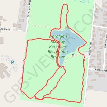
Traralgon Railway Reservoir Walk
- Distance: 1.9 mi
- Elevation gain: 141 ft
- Maximum elevation: 256 ft
- Elevation loss: 144 ft
- Minimum elevation: 184 ft
- Moving time: 38 m 1 s
- Moving speed: 3.0 mph
- Maximum speed: 4.0 mph
- Total time: 38 m 1 s
- Global speed: 3.0 mph
Interactive trail map
Thank you for supporting this site ❤️
Make a donation
Make a donation
Gear up for your next adventure:
As an Amazon Associate, this site earns from qualifying purchases at no extra cost to you.
Trail profile
- Distance: 1.9 mi
- Elevation gain: 141 ft
- Maximum elevation: 256 ft
- Elevation loss: 144 ft
- Minimum elevation: 184 ft
- Moving time: 38 m 1 s
- Moving speed: 3.0 mph
- Maximum speed: 4.0 mph
- Total time: 38 m 1 s
- Global speed: 3.0 mph
Thank you for supporting this site ❤️
Make a donation
Make a donation
Gear up for your next adventure:
As an Amazon Associate, this site earns from qualifying purchases at no extra cost to you.
About this trail
Name: Traralgon Railway Reservoir Walk trail, distance, elevation, map, profile, GPS track
Start: Hickox Street, Traralgon, City of Latrobe, Victoria, 3844, Australia (-38.21132 146.53087)
End: Hickox Street, Traralgon, City of Latrobe, Victoria, 3844, Australia (-38.21113 146.53084)
Coordinates: -38.21381 146.52603 -38.20795 146.53098
Thank you for supporting this site ❤️
Make a donation
Make a donation
Gear up for your next adventure:
As an Amazon Associate, this site earns from qualifying purchases at no extra cost to you.