Hocking Hills Rock House Trail
- Distance: 0.6 mi
- Elevation gain: 141 ft
- Maximum elevation: 1,109 ft
- Elevation loss: 148 ft
- Minimum elevation: 1,010 ft
- Moving time: 18 m 11 s
- Moving speed: 2.1 mph
- Maximum speed: 6.5 mph
- Total time: 22 m 13 s
- Global speed: 1.7 mph
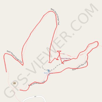
Interactive trail map
Trail profile
- Distance: 0.6 mi
- Elevation gain: 141 ft
- Maximum elevation: 1,109 ft
- Elevation loss: 148 ft
- Minimum elevation: 1,010 ft
- Moving time: 18 m 11 s
- Moving speed: 2.1 mph
- Maximum speed: 6.5 mph
- Total time: 22 m 13 s
- Global speed: 1.7 mph
About this trail
Name: Hocking Hills Rock House Trail trail, distance, elevation, map, profile, GPS track
Start: Rock House Rim Trail, Hocking County, Ohio, United States (39.49677 -82.61511)
End: Rock House Gorge Trail, Hocking County, Ohio, United States (39.49722 -82.61554)
Coordinates: 39.49675 -82.61563 39.49877 -82.61252
Topography: Hocking County topographic map, elevation, terrain
Other hiking, mountain biking, running and outdoor activity trails
Click on a trail to view its statistics, map and profile.
Rock House Cave and Falls Loop via Rock House Gorge Trail in Hocking Hills State Park
United States > Ohio > Hocking County
The Rock House Cave and Falls Loop offers a unique hiking experience characterized by stunning natural features and rich history. The loop trail leads you to the impressive Rock House, a sandstone cave with Gothic-arched windows and evidence of past human habitation, making it a fascinating stop for both…
Distance: 0.9 mi • Elevation gain: 177 ft • Maximum elevation: 1,152 ft