Thank you for supporting this site ❤️
Make a donation
Make a donation
Gear up for your next adventure:
As an Amazon Associate, this site earns from qualifying purchases at no extra cost to you.
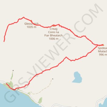
Munro hillwalk Gleouriach and Spidean Mialach
#Munro #Hillwalk #Gleouriach #Mialach
- Distance: 6.3 mi
- Elevation gain: 3,812 ft
- Maximum elevation: 3,360 ft
- Elevation loss: 2,064 ft
- Minimum elevation: 692 ft
- Moving time: 4 h 10 m
- Moving speed: 1.5 mph
- Maximum speed: 3.8 mph
- Total time: 4 h 50 m
- Global speed: 1.3 mph
Interactive trail map
Thank you for supporting this site ❤️
Make a donation
Make a donation
Gear up for your next adventure:
As an Amazon Associate, this site earns from qualifying purchases at no extra cost to you.
Trail profile
- Distance: 6.3 mi
- Elevation gain: 3,812 ft
- Maximum elevation: 3,360 ft
- Elevation loss: 2,064 ft
- Minimum elevation: 692 ft
- Moving time: 4 h 10 m
- Moving speed: 1.5 mph
- Maximum speed: 3.8 mph
- Total time: 4 h 50 m
- Global speed: 1.3 mph
Thank you for supporting this site ❤️
Make a donation
Make a donation
Gear up for your next adventure:
As an Amazon Associate, this site earns from qualifying purchases at no extra cost to you.
About this trail
Name: Munro hillwalk Gleouriach and Spidean Mialach trail, distance, elevation, map, profile, GPS track
Start: Highland, Scotland, United Kingdom (57.07589 -5.25372)
End: Highland, Scotland, United Kingdom (57.09004 -5.25493)
Coordinates: 57.07389 -5.25494 57.09821 -5.19363
Thank you for supporting this site ❤️
Make a donation
Make a donation
Gear up for your next adventure:
As an Amazon Associate, this site earns from qualifying purchases at no extra cost to you.