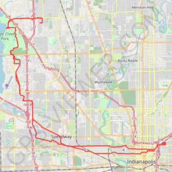
Indianapolis - Eagle Creek Park
Morning E-Bike Ride
- Distance: 39.8 mi
- Elevation gain: 607 ft
- Maximum elevation: 869 ft
- Elevation loss: 607 ft
- Minimum elevation: 689 ft
- Moving time: 2 h 46 m
- Moving speed: 14.3 mph
- Maximum speed: 30.7 mph
- Total time: 10 h 22 m
- Global speed: 3.8 mph
Interactive trail map
Trail profile
- Distance: 39.8 mi
- Elevation gain: 607 ft
- Maximum elevation: 869 ft
- Elevation loss: 607 ft
- Minimum elevation: 689 ft
- Moving time: 2 h 46 m
- Moving speed: 14.3 mph
- Maximum speed: 30.7 mph
- Total time: 10 h 22 m
- Global speed: 3.8 mph
About this trail
Name: Indianapolis - Eagle Creek Park trail, distance, elevation, map, profile, GPS track
Coordinates: 39.77415 -86.29702 39.88156 -86.13339
Topography: Indianapolis topographic map, elevation, terrain
Other hiking, mountain biking, running and outdoor activity trails
Click on a trail to view its statistics, map and profile.
Eagle Creek Park Loop via Red Trail
United States > Indiana > Marion County > Indianapolis
The Eagle Creek Park Loop via Red Trail offers a delightful escape into nature, characterized by scenic views of the Eagle Creek Reservoir and lush wooded areas. Hikers can enjoy encounters with local wildlife, including various bird species, amidst diverse plant life that enhances the trail's natural beauty.…
Distance: 7.0 mi • Elevation gain: 269 ft • Maximum elevation: 866 ft