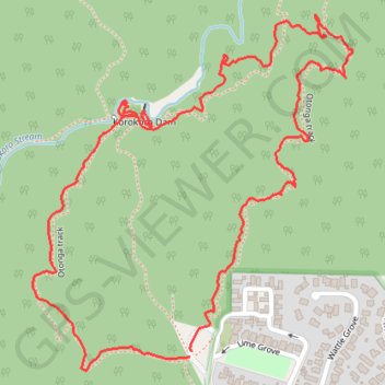
Korokoro Dam
Walking
- Distance: 1.8 mi
- Elevation gain: 512 ft
- Maximum elevation: 659 ft
- Elevation loss: 515 ft
- Minimum elevation: 259 ft
- Moving time: 45 m 28 s
- Moving speed: 2.4 mph
- Maximum speed: 5.2 mph
- Total time: 58 m 35 s
- Global speed: 1.9 mph
Interactive trail map
Trail profile
- Distance: 1.8 mi
- Elevation gain: 512 ft
- Maximum elevation: 659 ft
- Elevation loss: 515 ft
- Minimum elevation: 259 ft
- Moving time: 45 m 28 s
- Moving speed: 2.4 mph
- Maximum speed: 5.2 mph
- Total time: 58 m 35 s
- Global speed: 1.9 mph
About this trail
Name: Korokoro Dam trail, distance, elevation, map, profile, GPS track
Start: Maungaraki, Lower Hutt, Lower Hutt City, Wellington, 5045, New Zealand (-41.20199 174.87562)
End: Maungaraki, Lower Hutt, Lower Hutt City, Wellington, 5045, New Zealand (-41.20190 174.87565)
Coordinates: -41.20223 174.87197 -41.19600 174.87938
Other hiking, mountain biking, running and outdoor activity trails
Click on a trail to view its statistics, map and profile.
Belmont Trig Loop Walk
New Zealand > Wellington > Lower Hutt City > Lower Hutt
Distance: 6.9 mi • Elevation gain: 1,998 ft • Maximum elevation: 1,463 ft