Thank you for supporting this site ❤️
Make a donation
Make a donation
Gear up for your next adventure:
As an Amazon Associate, this site earns from qualifying purchases at no extra cost to you.
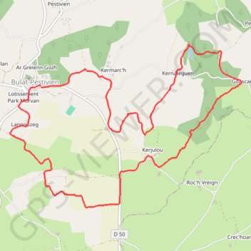
LGT : Bulat-Paetivien : le Circuit des Brigants
- Distance: 6.7 mi
- Elevation gain: 568 ft
- Maximum elevation: 951 ft
- Elevation loss: 568 ft
- Minimum elevation: 755 ft
- Moving time: 2 h 37 m
- Moving speed: 2.5 mph
- Maximum speed: 4.1 mph
- Total time: 2 h 51 m
- Global speed: 2.3 mph
Interactive trail map
Thank you for supporting this site ❤️
Make a donation
Make a donation
Gear up for your next adventure:
As an Amazon Associate, this site earns from qualifying purchases at no extra cost to you.
Trail profile
- Distance: 6.7 mi
- Elevation gain: 568 ft
- Maximum elevation: 951 ft
- Elevation loss: 568 ft
- Minimum elevation: 755 ft
- Moving time: 2 h 37 m
- Moving speed: 2.5 mph
- Maximum speed: 4.1 mph
- Total time: 2 h 51 m
- Global speed: 2.3 mph
Thank you for supporting this site ❤️
Make a donation
Make a donation
Gear up for your next adventure:
As an Amazon Associate, this site earns from qualifying purchases at no extra cost to you.
About this trail
Name: LGT : Bulat-Paetivien : le Circuit des Brigants trail, distance, elevation, map, profile, GPS track
Coordinates: 48.41535 -3.33437 48.43300 -3.29664
Thank you for supporting this site ❤️
Make a donation
Make a donation
Gear up for your next adventure:
As an Amazon Associate, this site earns from qualifying purchases at no extra cost to you.