Thank you for supporting this site ❤️
Make a donation
Make a donation
Gear up for your next adventure:
As an Amazon Associate, this site earns from qualifying purchases at no extra cost to you.
Maligne Lake - Opal Hills Loop
Interactive trail map
Thank you for supporting this site ❤️
Make a donation
Make a donation
Gear up for your next adventure:
As an Amazon Associate, this site earns from qualifying purchases at no extra cost to you.
Trail profile
- Distance: 4.7 mi
- Elevation gain: 1,601 ft
- Maximum elevation: 7,090 ft
- Elevation loss: 1,611 ft
- Minimum elevation: 5,551 ft
Thank you for supporting this site ❤️
Make a donation
Make a donation
Gear up for your next adventure:
As an Amazon Associate, this site earns from qualifying purchases at no extra cost to you.
About this trail
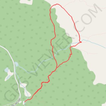
Name: Maligne Lake - Opal Hills Loop trail, distance, elevation, map, profile, GPS track
Start: Opal Hills Loop, Improvement District No. 12, Alberta, Canada (52.73285 -117.63070)
End: Mary Schaeffer Loop, Improvement District No. 12, Alberta, Canada (52.73091 -117.63459)
Coordinates: 52.73091 -117.63459 52.75576 -117.61082
Thank you for supporting this site ❤️
Make a donation
Make a donation
Gear up for your next adventure:
As an Amazon Associate, this site earns from qualifying purchases at no extra cost to you.
Other hiking, mountain biking, running and outdoor activity trails
Click on a trail to view its statistics, map and profile.