Thank you for supporting this site ❤️
Make a donation
Make a donation
Gear up for your next adventure:
As an Amazon Associate, this site earns from qualifying purchases at no extra cost to you.
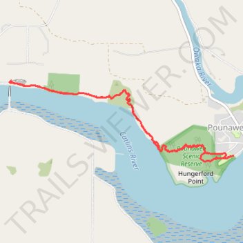
Pounawea Bush Walk via Hinahina Track
- Distance: 4.1 mi
- Elevation gain: 328 ft
- Maximum elevation: 105 ft
- Elevation loss: 328 ft
- Minimum elevation: 3 ft
- Moving time: 1 h 24 m
- Moving speed: 2.9 mph
- Maximum speed: 4.5 mph
- Total time: 1 h 46 m
- Global speed: 2.3 mph
Interactive trail map
Thank you for supporting this site ❤️
Make a donation
Make a donation
Gear up for your next adventure:
As an Amazon Associate, this site earns from qualifying purchases at no extra cost to you.
Trail profile
- Distance: 4.1 mi
- Elevation gain: 328 ft
- Maximum elevation: 105 ft
- Elevation loss: 328 ft
- Minimum elevation: 3 ft
- Moving time: 1 h 24 m
- Moving speed: 2.9 mph
- Maximum speed: 4.5 mph
- Total time: 1 h 46 m
- Global speed: 2.3 mph
Thank you for supporting this site ❤️
Make a donation
Make a donation
Gear up for your next adventure:
As an Amazon Associate, this site earns from qualifying purchases at no extra cost to you.
About this trail
Name: Pounawea Bush Walk via Hinahina Track trail, distance, elevation, map, profile, GPS track
Start: 1, Park Lane, Pounawea, Clutha District, Otago, 9535, New Zealand (-46.47588 169.69387)
End: Park Lane, Pounawea, Clutha District, Otago, 9535, New Zealand (-46.47589 169.69377)
Coordinates: -46.47641 169.66372 -46.46899 169.69387
Thank you for supporting this site ❤️
Make a donation
Make a donation
Gear up for your next adventure:
As an Amazon Associate, this site earns from qualifying purchases at no extra cost to you.
Other hiking, mountain biking, running and outdoor activity trails
Click on a trail to view its statistics, map and profile.