Make a donation
Gear up for your next adventure:
As an Amazon Associate, this site earns from qualifying purchases at no extra cost to you.
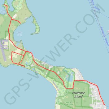
Prudence Island
Portsmouth Running
- Distance: 9.7 mi
- Elevation gain: 318 ft
- Maximum elevation: 59 ft
- Elevation loss: 308 ft
- Minimum elevation: -10 ft
- Moving time: 1 h 45 m
- Moving speed: 5.5 mph
- Maximum speed: 9.3 mph
- Total time: 2 h 1 m
- Global speed: 4.8 mph
Interactive trail map
Make a donation
Gear up for your next adventure:
As an Amazon Associate, this site earns from qualifying purchases at no extra cost to you.
Trail profile
- Distance: 9.7 mi
- Elevation gain: 318 ft
- Maximum elevation: 59 ft
- Elevation loss: 308 ft
- Minimum elevation: -10 ft
- Moving time: 1 h 45 m
- Moving speed: 5.5 mph
- Maximum speed: 9.3 mph
- Total time: 2 h 1 m
- Global speed: 4.8 mph
Make a donation
Gear up for your next adventure:
As an Amazon Associate, this site earns from qualifying purchases at no extra cost to you.
About this trail
Name: Prudence Island trail, distance, elevation, map, profile, GPS track
Coordinates: 41.61970 -71.34798 41.65163 -71.30488
Topography: Newport County topographic map, elevation, terrain
Make a donation
Gear up for your next adventure:
As an Amazon Associate, this site earns from qualifying purchases at no extra cost to you.
Other hiking, mountain biking, running and outdoor activity trails
Click on a trail to view its statistics, map and profile.
Prudence Island
United States > Rhode Island > Newport County > Portsmouth
Portsmouth Running
Distance: 13.7 mi • Elevation gain: 876 ft • Maximum elevation: 157 ft