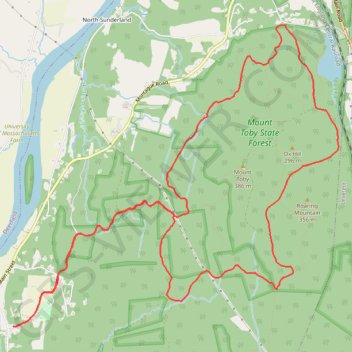
Mount Toby Loop Trail Run
Sunderland Trail Running
- Distance: 10.6 mi
- Elevation gain: 1,427 ft
- Maximum elevation: 1,066 ft
- Elevation loss: 1,434 ft
- Minimum elevation: 187 ft
- Moving time: 2 h 1 m
- Moving speed: 5.3 mph
- Maximum speed: 9.5 mph
- Total time: 2 h 2 m
- Global speed: 5.2 mph
Interactive trail map
Trail profile
- Distance: 10.6 mi
- Elevation gain: 1,427 ft
- Maximum elevation: 1,066 ft
- Elevation loss: 1,434 ft
- Minimum elevation: 187 ft
- Moving time: 2 h 1 m
- Moving speed: 5.3 mph
- Maximum speed: 9.5 mph
- Total time: 2 h 2 m
- Global speed: 5.2 mph
About this trail
Name: Mount Toby Loop Trail Run trail, distance, elevation, map, profile, GPS track
Start: 14, Park Road, Sunderland, Franklin County, Massachusetts, 01375, United States (42.47049 -72.57133)
End: 11, Park Road, Sunderland, Franklin County, Massachusetts, 01375, United States (42.47042 -72.57181)
Coordinates: 42.47040 -72.57181 42.50361 -72.52322
Topography: Franklin County topographic map, elevation, terrain
Other hiking, mountain biking, running and outdoor activity trails
Click on a trail to view its statistics, map and profile.
Summit Bypass & Hidden Hill Upper
United States > Massachusetts > Franklin County > Sunderland
Mount Toby State Forest Trail Running
Distance: 9.0 mi • Elevation gain: 1,237 ft • Maximum elevation: 896 ft
Summit Alt & Downspout
United States > Massachusetts > Franklin County > Sunderland
Mount Toby State Forest Trail Running
Distance: 6.2 mi • Elevation gain: 810 ft • Maximum elevation: 899 ft
Under Cliffs
United States > Massachusetts > Franklin County > Sunderland
Distance: 4.4 mi • Elevation gain: 495 ft • Maximum elevation: 587 ft
Cave Trails
United States > Massachusetts > Franklin County > Sunderland
Distance: 6.2 mi • Elevation gain: 584 ft • Maximum elevation: 617 ft