Thank you for supporting this site ❤️
Make a donation
Make a donation
Gear up for your next adventure:
As an Amazon Associate, this site earns from qualifying purchases at no extra cost to you.
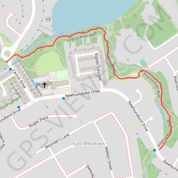
Virginia River Walk
- Distance: 0.7 mi
- Elevation gain: 3 ft
- Maximum elevation: 246 ft
- Elevation loss: 46 ft
- Minimum elevation: 200 ft
- Moving time: 14 m 45 s
- Moving speed: 2.9 mph
- Maximum speed: 4.3 mph
- Total time: 18 m 40 s
- Global speed: 2.3 mph
Interactive trail map
Thank you for supporting this site ❤️
Make a donation
Make a donation
Gear up for your next adventure:
As an Amazon Associate, this site earns from qualifying purchases at no extra cost to you.
Trail profile
- Distance: 0.7 mi
- Elevation gain: 3 ft
- Maximum elevation: 246 ft
- Elevation loss: 46 ft
- Minimum elevation: 200 ft
- Moving time: 14 m 45 s
- Moving speed: 2.9 mph
- Maximum speed: 4.3 mph
- Total time: 18 m 40 s
- Global speed: 2.3 mph
Thank you for supporting this site ❤️
Make a donation
Make a donation
Gear up for your next adventure:
As an Amazon Associate, this site earns from qualifying purchases at no extra cost to you.
About this trail
Name: Virginia River Walk trail, distance, elevation, map, profile, GPS track
Coordinates: 47.59950 -52.70840 47.60384 -52.69967
Thank you for supporting this site ❤️
Make a donation
Make a donation
Gear up for your next adventure:
As an Amazon Associate, this site earns from qualifying purchases at no extra cost to you.