Thank you for supporting this site ❤️
Make a donation
Make a donation
Gear up for your next adventure:
As an Amazon Associate, this site earns from qualifying purchases at no extra cost to you.
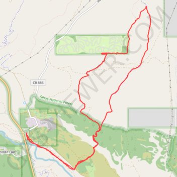
Hobart Mills - Overland trail - Exploration
Tahoe National Forest
- Distance: 8.6 mi
- Elevation gain: 876 ft
- Maximum elevation: 6,378 ft
- Elevation loss: 883 ft
- Minimum elevation: 5,781 ft
Interactive trail map
Thank you for supporting this site ❤️
Make a donation
Make a donation
Gear up for your next adventure:
As an Amazon Associate, this site earns from qualifying purchases at no extra cost to you.
Trail profile
- Distance: 8.6 mi
- Elevation gain: 876 ft
- Maximum elevation: 6,378 ft
- Elevation loss: 883 ft
- Minimum elevation: 5,781 ft
Thank you for supporting this site ❤️
Make a donation
Make a donation
Gear up for your next adventure:
As an Amazon Associate, this site earns from qualifying purchases at no extra cost to you.
About this trail
Name: Hobart Mills - Overland trail - Exploration trail, distance, elevation, map, profile, GPS track
Coordinates: 39.39091 -120.18702 39.42355 -120.15489
Topography: Nevada County topographic map, elevation, terrain
Thank you for supporting this site ❤️
Make a donation
Make a donation
Gear up for your next adventure:
As an Amazon Associate, this site earns from qualifying purchases at no extra cost to you.