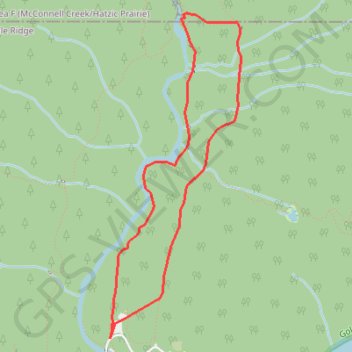
Lower Falls - East Canyon Trail
Golden Ears Provincial Park. #Hiking #Loop #GoldenEars
- Distance: 3.6 mi
- Elevation gain: 502 ft
- Maximum elevation: 968 ft
- Elevation loss: 502 ft
- Minimum elevation: 482 ft
Interactive trail map
Trail profile
- Distance: 3.6 mi
- Elevation gain: 502 ft
- Maximum elevation: 968 ft
- Elevation loss: 502 ft
- Minimum elevation: 482 ft
About this trail
Name: Lower Falls - East Canyon Trail trail, distance, elevation, map, profile, GPS track
Coordinates: 49.33297 -122.45798 49.35370 -122.44517
Other hiking, mountain biking, running and outdoor activity trails
Click on a trail to view its statistics, map and profile.
Gold Creek Valley
Canada > British Columbia > Metro Vancouver Regional District > Maple Ridge
Golden Ears Provincial Park. #Hiking #Loop #GoldenEars
Distance: 6.5 mi • Elevation gain: 1,381 ft • Maximum elevation: 1,201 ft