Silver Creek Loop Trail in Jay Cooke State Park
The Silver Creek Loop Trail offers a memorable outdoor experience, showcasing a variety of natural elements. Hikers are greeted with picturesque views of the St. Louis River and Silver Creek, as well as sections of dense hardwood forests filled with birch and basswood trees. Along the route, the landscape features occasional rocky terrain and gentle inclines, offering glimpses of wildflowers, including yellow lady's slippers in the spring. The trail provides a peaceful escape into nature, with occasional scenic vistas over the water and an enjoyable crossing on the park’s historic Swinging Bridge. #Hiking #Loop #River #Forest #Nature
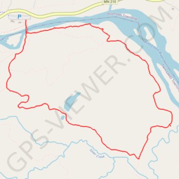
- Distance: 3.4 mi
- Elevation gain: 302 ft
- Maximum elevation: 965 ft
- Elevation loss: 322 ft
- Minimum elevation: 712 ft
- Moving time: 1 h 28 m
- Moving speed: 2.3 mph
- Maximum speed: 4.0 mph
- Total time: 1 h 37 m
- Global speed: 2.1 mph
Interactive trail map
Trail profile
- Distance: 3.4 mi
- Elevation gain: 302 ft
- Maximum elevation: 965 ft
- Elevation loss: 322 ft
- Minimum elevation: 712 ft
- Moving time: 1 h 28 m
- Moving speed: 2.3 mph
- Maximum speed: 4.0 mph
- Total time: 1 h 37 m
- Global speed: 2.1 mph
About this trail
Name: Silver Creek Loop Trail in Jay Cooke State Park trail, distance, elevation, map, profile, GPS track
Start: MN 210, Carlton, Thomson Township, Carlton County, Minnesota, United States (46.65452 -92.37047)
End: Swinging Bridge, Thomson Township, Carlton County, Minnesota, United States (46.65406 -92.37046)
Coordinates: 46.64247 -92.37290 46.65452 -92.35198
Topography: Carlton County topographic map, elevation, terrain
Other hiking, mountain biking, running and outdoor activity trails
Click on a trail to view its statistics, map and profile.