Thank you for supporting this site ❤️
Make a donation
Make a donation
Gear up for your next adventure:
As an Amazon Associate, this site earns from qualifying purchases at no extra cost to you.
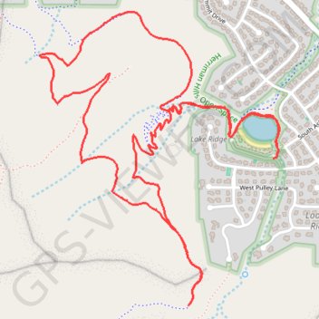
Herriman Hills Open Space
- Distance: 4.4 mi
- Elevation gain: 623 ft
- Maximum elevation: 5,676 ft
- Elevation loss: 617 ft
- Minimum elevation: 5,233 ft
- Moving time: 1 h 37 m
- Moving speed: 2.7 mph
- Maximum speed: 3.6 mph
- Total time: 1 h 41 m
- Global speed: 2.6 mph
Interactive trail map
Thank you for supporting this site ❤️
Make a donation
Make a donation
Gear up for your next adventure:
As an Amazon Associate, this site earns from qualifying purchases at no extra cost to you.
Trail profile
- Distance: 4.4 mi
- Elevation gain: 623 ft
- Maximum elevation: 5,676 ft
- Elevation loss: 617 ft
- Minimum elevation: 5,233 ft
- Moving time: 1 h 37 m
- Moving speed: 2.7 mph
- Maximum speed: 3.6 mph
- Total time: 1 h 41 m
- Global speed: 2.6 mph
Thank you for supporting this site ❤️
Make a donation
Make a donation
Gear up for your next adventure:
As an Amazon Associate, this site earns from qualifying purchases at no extra cost to you.
About this trail
Name: Herriman Hills Open Space trail, distance, elevation, map, profile, GPS track
Coordinates: 40.47301 -112.03306 40.48551 -112.01970
Topography: Salt Lake County topographic map, elevation, terrain
Thank you for supporting this site ❤️
Make a donation
Make a donation
Gear up for your next adventure:
As an Amazon Associate, this site earns from qualifying purchases at no extra cost to you.
Other hiking, mountain biking, running and outdoor activity trails
Click on a trail to view its statistics, map and profile.
Herriman Hills Open Space
United States > Utah > Salt Lake County > Herriman
Distance: 12.1 mi • Elevation gain: 1,831 ft • Maximum elevation: 6,070 ft