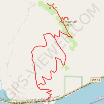
Dog Mountain Loop
Interactive trail map
Trail profile
- Distance: 6.6 mi
- Elevation gain: 3,077 ft
- Maximum elevation: 2,917 ft
- Elevation loss: 3,074 ft
- Minimum elevation: 131 ft
About this trail
Name: Dog Mountain Loop trail, distance, elevation, map, profile, GPS track
Start: Dog Mountain Trail, Skamania County, Washington, United States (45.69934 -121.70815)
End: Dog Mountain Trail, Skamania County, Washington, United States (45.69935 -121.70812)
Coordinates: 45.69927 -121.71166 45.72010 -121.69912
Topography: Skamania County topographic map, elevation, terrain
Other hiking, mountain biking, running and outdoor activity trails
Click on a trail to view its statistics, map and profile.
Dog Mountain Loop Trail in Gifford Pinchot National Forest
United States > Washington > Skamania County
The Dog Mountain Loop Trail offers a challenging and rewarding hike with panoramic views of the Columbia River Gorge. Hikers will traverse diverse landscapes, from lush forests and meadows filled with wildflowers to rocky outcrops and steep sections leading to a summit with expansive vistas. The trail's…
Distance: 5.9 mi • Elevation gain: 2,776 ft • Maximum elevation: 2,867 ft
Dog Mountain Trail and Augspurger Trail Loop in Gifford Pinchot National Forest
United States > Washington > Skamania County
The Dog Mountain and Augspurger Trail Loop offers an unforgettable experience, featuring spectacular wildflower meadows and sweeping vistas of the Columbia River Gorge. As you ascend, you’ll traverse a variety of terrains—from lush forests to rocky, exposed ridgelines—while being rewarded with panoramic…
Distance: 6.8 mi • Elevation gain: 2,851 ft • Maximum elevation: 2,913 ft
Dog Mountain Loop Trail in Columbia River Gorge National Scenic Area
United States > Washington > Skamania County
The Dog Mountain Loop Trail in Columbia River Gorge National Scenic Area offers hikers a stunning combination of vibrant wildflower fields, expansive views of the gorge, and dramatic mountain landscapes. As you ascend the trail, you'll be treated to panoramic vistas of the Columbia River and surrounding…
Distance: 5.8 mi • Elevation gain: 2,802 ft • Maximum elevation: 2,913 ft
Northern part of the Pacific Crest Trail (PCT)
United States > Oregon > Klamath County
Hike on the Pacific Crest National Scenic Trail from Crater Lake to Canada Border through Oregon and Washington along the Sierra Nevada and Cascade mountain ranges. #Hiking #Mountain #SierraNevada #Cascade #Nature #Forest #Park #PCT
Distance: 744.6 mi • Elevation gain: 145,367 ft • Maximum elevation: 7,569 ft