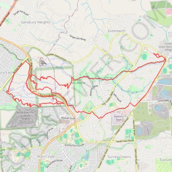
Cobbler Creek Recreation Park
- Distance: 12.5 mi
- Elevation gain: 1,175 ft
- Maximum elevation: 719 ft
- Elevation loss: 1,175 ft
- Minimum elevation: 259 ft
- Moving time: 1 h 27 m
- Moving speed: 8.6 mph
- Maximum speed: 24.9 mph
- Total time: 1 h 31 m
- Global speed: 8.2 mph
Interactive trail map
Trail profile
- Distance: 12.5 mi
- Elevation gain: 1,175 ft
- Maximum elevation: 719 ft
- Elevation loss: 1,175 ft
- Minimum elevation: 259 ft
- Moving time: 1 h 27 m
- Moving speed: 8.6 mph
- Maximum speed: 24.9 mph
- Total time: 1 h 31 m
- Global speed: 8.2 mph
About this trail
Name: Cobbler Creek Recreation Park trail, distance, elevation, map, profile, GPS track
Coordinates: -34.78918 138.67411 -34.77130 138.72700
Other hiking, mountain biking, running and outdoor activity trails
Click on a trail to view its statistics, map and profile.
Cobbler Creek Recreation Park and Martindale Reserve
Australia > South Australia > Adelaide
Distance: 18.7 mi • Elevation gain: 2,201 ft • Maximum elevation: 719 ft
Dry Creek to the Triangle
Australia > South Australia > Adelaide
Distance: 13.2 mi • Elevation gain: 571 ft • Maximum elevation: 669 ft
Greenwith Rando Walk
Australia > South Australia > Adelaide
Distance: 6.3 mi • Elevation gain: 689 ft • Maximum elevation: 712 ft
Goldenfields Reserve
Australia > South Australia > Adelaide
Walkin' while the kids were playin'
Distance: 1.6 mi • Elevation gain: 167 ft • Maximum elevation: 689 ft
Dry Creek Trail
Australia > South Australia > Adelaide
Distance: 14.0 mi • Elevation gain: 863 ft • Maximum elevation: 669 ft
The Stables Reserve - Walk
Australia > South Australia > Adelaide
Distance: 1.2 mi • Elevation gain: 72 ft • Maximum elevation: 669 ft