Make a donation
Gear up for your next adventure:
As an Amazon Associate, this site earns from qualifying purchases at no extra cost to you.
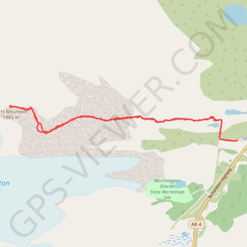
Girls Mountain route
- Distance: 7.7 mi
- Elevation gain: 4,039 ft
- Maximum elevation: 6,079 ft
- Elevation loss: 4,042 ft
- Minimum elevation: 2,083 ft
- Moving time: 4 h 16 m
- Moving speed: 1.8 mph
- Maximum speed: 5.9 mph
- Total time: 7 h 54 m
- Global speed: 1.0 mph
Interactive trail map
Make a donation
Gear up for your next adventure:
As an Amazon Associate, this site earns from qualifying purchases at no extra cost to you.
Trail profile
- Distance: 7.7 mi
- Elevation gain: 4,039 ft
- Maximum elevation: 6,079 ft
- Elevation loss: 4,042 ft
- Minimum elevation: 2,083 ft
- Moving time: 4 h 16 m
- Moving speed: 1.8 mph
- Maximum speed: 5.9 mph
- Total time: 7 h 54 m
- Global speed: 1.0 mph
Make a donation
Gear up for your next adventure:
As an Amazon Associate, this site earns from qualifying purchases at no extra cost to you.
About this trail
Name: Girls Mountain route trail, distance, elevation, map, profile, GPS track
Start: Richardson Highway, Ptarmigan, Unorganized Borough, Alaska, United States (61.17600 -145.69536)
End: Richardson Highway, Ptarmigan, Unorganized Borough, Alaska, United States (61.17607 -145.69405)
Coordinates: 61.17599 -145.77659 61.18211 -145.69405
Topography: Unorganized Borough topographic map, elevation, terrain
Make a donation
Gear up for your next adventure:
As an Amazon Associate, this site earns from qualifying purchases at no extra cost to you.