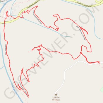
Leatherwook Loop Trail
Scott County Hiking
- Distance: 4.0 mi
- Elevation gain: 755 ft
- Maximum elevation: 1,467 ft
- Elevation loss: 755 ft
- Minimum elevation: 889 ft
- Moving time: 1 h 5 m
- Moving speed: 3.6 mph
- Maximum speed: 24.6 mph
- Total time: 1 h 5 m
- Global speed: 3.6 mph
Interactive trail map
Trail profile
- Distance: 4.0 mi
- Elevation gain: 755 ft
- Maximum elevation: 1,467 ft
- Elevation loss: 755 ft
- Minimum elevation: 889 ft
- Moving time: 1 h 5 m
- Moving speed: 3.6 mph
- Maximum speed: 24.6 mph
- Total time: 1 h 5 m
- Global speed: 3.6 mph
About this trail
Name: Leatherwook Loop Trail trail, distance, elevation, map, profile, GPS track
Start: Scott County, East Tennessee, Tennessee, United States (36.47765 -84.66794)
End: Scott County, East Tennessee, Tennessee, United States (36.47766 -84.66797)
Coordinates: 36.46916 -84.66839 36.47818 -84.65669
Topography: Scott County topographic map, elevation, terrain
Other hiking, mountain biking, running and outdoor activity trails
Click on a trail to view its statistics, map and profile.