Thank you for supporting this site ❤️
Make a donation
Make a donation
Gear up for your next adventure:
As an Amazon Associate, this site earns from qualifying purchases at no extra cost to you.
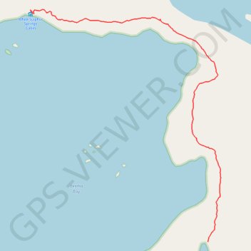
White Sulfur Springs Hike
Hotspring Hike
- Distance: 0.9 mi
- Elevation gain: 75 ft
- Maximum elevation: 52 ft
- Elevation loss: 79 ft
- Minimum elevation: 7 ft
- Moving time: 28 m 49 s
- Moving speed: 2.0 mph
- Maximum speed: 3.6 mph
- Total time: 44 m 53 s
- Global speed: 1.3 mph
Interactive trail map
Thank you for supporting this site ❤️
Make a donation
Make a donation
Gear up for your next adventure:
As an Amazon Associate, this site earns from qualifying purchases at no extra cost to you.
Trail profile
- Distance: 0.9 mi
- Elevation gain: 75 ft
- Maximum elevation: 52 ft
- Elevation loss: 79 ft
- Minimum elevation: 7 ft
- Moving time: 28 m 49 s
- Moving speed: 2.0 mph
- Maximum speed: 3.6 mph
- Total time: 44 m 53 s
- Global speed: 1.3 mph
Thank you for supporting this site ❤️
Make a donation
Make a donation
Gear up for your next adventure:
As an Amazon Associate, this site earns from qualifying purchases at no extra cost to you.
About this trail
Name: White Sulfur Springs Hike trail, distance, elevation, map, profile, GPS track
Start: Sitka, Alaska, 99835, United States (57.79834 -136.33341)
End: White Sulphur Springs Cabin, Sitka, Alaska, United States (57.80551 -136.34375)
Coordinates: 57.79834 -136.34378 57.80558 -136.33266
Topography: Sitka topographic map, elevation, terrain
Thank you for supporting this site ❤️
Make a donation
Make a donation
Gear up for your next adventure:
As an Amazon Associate, this site earns from qualifying purchases at no extra cost to you.