Thank you for supporting this site ❤️
Make a donation
Make a donation
Gear up for your next adventure:
As an Amazon Associate, this site earns from qualifying purchases at no extra cost to you.
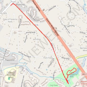
Baltimore & Annapolis Trail to Cattail Creek Natural Area
- Distance: 3.4 mi
- Elevation gain: 144 ft
- Maximum elevation: 79 ft
- Elevation loss: 144 ft
- Minimum elevation: 7 ft
- Moving time: 1 h 12 m
- Moving speed: 2.8 mph
- Maximum speed: 4.6 mph
- Total time: 1 h 16 m
- Global speed: 2.7 mph
Interactive trail map
Thank you for supporting this site ❤️
Make a donation
Make a donation
Gear up for your next adventure:
As an Amazon Associate, this site earns from qualifying purchases at no extra cost to you.
Trail profile
- Distance: 3.4 mi
- Elevation gain: 144 ft
- Maximum elevation: 79 ft
- Elevation loss: 144 ft
- Minimum elevation: 7 ft
- Moving time: 1 h 12 m
- Moving speed: 2.8 mph
- Maximum speed: 4.6 mph
- Total time: 1 h 16 m
- Global speed: 2.7 mph
Thank you for supporting this site ❤️
Make a donation
Make a donation
Gear up for your next adventure:
As an Amazon Associate, this site earns from qualifying purchases at no extra cost to you.
About this trail
Name: Baltimore & Annapolis Trail to Cattail Creek Natural Area trail, distance, elevation, map, profile, GPS track
Coordinates: 39.08175 -76.56981 39.09728 -76.55352
Topography: Anne Arundel County topographic map, elevation, terrain
Thank you for supporting this site ❤️
Make a donation
Make a donation
Gear up for your next adventure:
As an Amazon Associate, this site earns from qualifying purchases at no extra cost to you.