Thank you for supporting this site ❤️
Make a donation
Make a donation
Gear up for your next adventure:
As an Amazon Associate, this site earns from qualifying purchases at no extra cost to you.
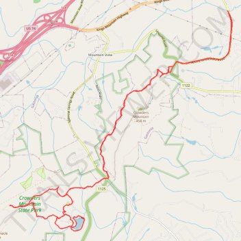
Crowders Mountain State Park
- Distance: 14.0 mi
- Elevation gain: 1,575 ft
- Maximum elevation: 1,178 ft
- Elevation loss: 1,575 ft
- Minimum elevation: 689 ft
- Moving time: 2 h 22 m
- Moving speed: 5.9 mph
- Maximum speed: 11.8 mph
- Total time: 2 h 22 m
- Global speed: 5.9 mph
Interactive trail map
Thank you for supporting this site ❤️
Make a donation
Make a donation
Gear up for your next adventure:
As an Amazon Associate, this site earns from qualifying purchases at no extra cost to you.
Trail profile
- Distance: 14.0 mi
- Elevation gain: 1,575 ft
- Maximum elevation: 1,178 ft
- Elevation loss: 1,575 ft
- Minimum elevation: 689 ft
- Moving time: 2 h 22 m
- Moving speed: 5.9 mph
- Maximum speed: 11.8 mph
- Total time: 2 h 22 m
- Global speed: 5.9 mph
Thank you for supporting this site ❤️
Make a donation
Make a donation
Gear up for your next adventure:
As an Amazon Associate, this site earns from qualifying purchases at no extra cost to you.
About this trail
Name: Crowders Mountain State Park trail, distance, elevation, map, profile, GPS track
Start: Tower Trail, Gastonia, Gaston County, North Carolina, United States (35.24035 -81.26938)
End: Tower Trail, Gastonia, Gaston County, North Carolina, United States (35.24044 -81.26941)
Coordinates: 35.20742 -81.30922 35.25260 -81.25346
Topography: Gastonia topographic map, elevation, terrain
Thank you for supporting this site ❤️
Make a donation
Make a donation
Gear up for your next adventure:
As an Amazon Associate, this site earns from qualifying purchases at no extra cost to you.