Thank you for supporting this site ❤️
Make a donation
Make a donation
Gear up for your next adventure:
As an Amazon Associate, this site earns from qualifying purchases at no extra cost to you.
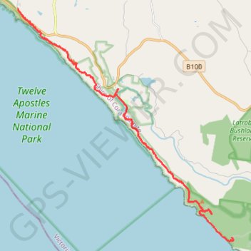
Wreck Beach - Twelve Apostles
Twelve Apostles Marine National Park. #Hiking #TwelveApostles
- Distance: 11.9 mi
- Elevation gain: 1,545 ft
- Maximum elevation: 322 ft
- Elevation loss: 1,614 ft
- Minimum elevation: -3 ft
Interactive trail map
Thank you for supporting this site ❤️
Make a donation
Make a donation
Gear up for your next adventure:
As an Amazon Associate, this site earns from qualifying purchases at no extra cost to you.
Trail profile
- Distance: 11.9 mi
- Elevation gain: 1,545 ft
- Maximum elevation: 322 ft
- Elevation loss: 1,614 ft
- Minimum elevation: -3 ft
Thank you for supporting this site ❤️
Make a donation
Make a donation
Gear up for your next adventure:
As an Amazon Associate, this site earns from qualifying purchases at no extra cost to you.
About this trail
Name: Wreck Beach - Twelve Apostles trail, distance, elevation, map, profile, GPS track
End: Great Ocean Walk, Princetown, Shire of Corangamite, Victoria, 3269, Australia (-38.66219 143.10492)
Coordinates: -38.75508 143.10492 -38.66219 143.21555
Thank you for supporting this site ❤️
Make a donation
Make a donation
Gear up for your next adventure:
As an Amazon Associate, this site earns from qualifying purchases at no extra cost to you.