Make a donation
Gear up for your next adventure:
As an Amazon Associate, this site earns from qualifying purchases at no extra cost to you.
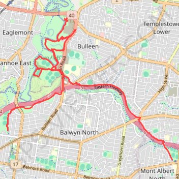
Elgar Park to Hays Paddock including Bolin Bolin Trail
- Distance: 11.2 mi
- Elevation gain: 381 ft
- Maximum elevation: 190 ft
- Elevation loss: 476 ft
- Minimum elevation: 39 ft
- Moving time: 1 h 51 m
- Moving speed: 6.0 mph
- Maximum speed: 23.1 mph
- Total time: 2 h 1 m
- Global speed: 5.5 mph
Interactive trail map
Make a donation
Gear up for your next adventure:
As an Amazon Associate, this site earns from qualifying purchases at no extra cost to you.
Trail profile
- Distance: 11.2 mi
- Elevation gain: 381 ft
- Maximum elevation: 190 ft
- Elevation loss: 476 ft
- Minimum elevation: 39 ft
- Moving time: 1 h 51 m
- Moving speed: 6.0 mph
- Maximum speed: 23.1 mph
- Total time: 2 h 1 m
- Global speed: 5.5 mph
Make a donation
Gear up for your next adventure:
As an Amazon Associate, this site earns from qualifying purchases at no extra cost to you.
About this trail
Name: Elgar Park to Hays Paddock including Bolin Bolin Trail trail, distance, elevation, map, profile, GPS track
Coordinates: -37.79951 145.05970 -37.76149 145.11586
Make a donation
Gear up for your next adventure:
As an Amazon Associate, this site earns from qualifying purchases at no extra cost to you.
Other hiking, mountain biking, running and outdoor activity trails
Click on a trail to view its statistics, map and profile.
Tallarook - Eildon - Hurstbridge
Australia > Victoria > Tallarook
#Bike
Distance: 173.2 mi • Elevation gain: 16,066 ft • Maximum elevation: 2,848 ft
Make a donation
Gear up for your next adventure:
As an Amazon Associate, this site earns from qualifying purchases at no extra cost to you.
Ashburton to Mernda (cycle)
Australia > Victoria > Melbourne
Distance: 26.2 mi • Elevation gain: 1,286 ft • Maximum elevation: 535 ft