Bicycle-Madison AL
Afternoon Ride
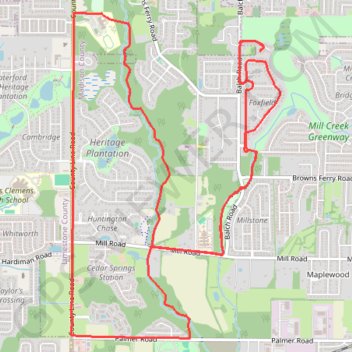
- Distance: 10.3 mi
- Elevation gain: 338 ft
- Maximum elevation: 728 ft
- Elevation loss: 338 ft
- Minimum elevation: 640 ft
- Moving time: 44 m 5 s
- Moving speed: 14.0 mph
- Maximum speed: 23.4 mph
- Total time: 45 m 33 s
- Global speed: 13.6 mph
Interactive trail map
Trail profile
- Distance: 10.3 mi
- Elevation gain: 338 ft
- Maximum elevation: 728 ft
- Elevation loss: 338 ft
- Minimum elevation: 640 ft
- Moving time: 44 m 5 s
- Moving speed: 14.0 mph
- Maximum speed: 23.4 mph
- Total time: 45 m 33 s
- Global speed: 13.6 mph
About this trail
Name: Bicycle-Madison AL trail, distance, elevation, map, profile, GPS track
Coordinates: 34.69227 -86.78656 34.72176 -86.76356
Topography: Madison County topographic map, elevation, terrain
Other hiking, mountain biking, running and outdoor activity trails
Click on a trail to view its statistics, map and profile.
13 Mile Bike, Madison, AL
United States > Alabama > Madison County > Madison
Distance: 13.0 mi • Elevation gain: 420 ft • Maximum elevation: 728 ft
10 Mile Run, Madison AL
United States > Alabama > Madison County > Madison
Lunch Run
Distance: 10.2 mi • Elevation gain: 328 ft • Maximum elevation: 728 ft
Bradford Creek Greenway
United States > Alabama > Madison County > Madison
Distance: 4.5 mi • Elevation gain: 121 ft • Maximum elevation: 702 ft
Bradford Creek Greenway
United States > Alabama > Madison County > Madison
Distance: 5.0 mi • Elevation gain: 121 ft • Maximum elevation: 705 ft