Thank you for supporting this site ❤️
Make a donation
Make a donation
Gear up for your next adventure:
As an Amazon Associate, this site earns from qualifying purchases at no extra cost to you.
Chilnualna Falls
Interactive trail map
Thank you for supporting this site ❤️
Make a donation
Make a donation
Gear up for your next adventure:
As an Amazon Associate, this site earns from qualifying purchases at no extra cost to you.
Trail profile
- Distance: 4.0 mi
- Elevation gain: 2,474 ft
- Maximum elevation: 6,437 ft
- Elevation loss: 230 ft
- Minimum elevation: 4,190 ft
Thank you for supporting this site ❤️
Make a donation
Make a donation
Gear up for your next adventure:
As an Amazon Associate, this site earns from qualifying purchases at no extra cost to you.
About this trail
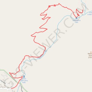
Name: Chilnualna Falls trail, distance, elevation, map, profile, GPS track
End: Chilnualna Falls Trail, Mariposa County, California, United States (37.56517 -119.61536)
Coordinates: 37.54820 -119.63533 37.56652 -119.61536
Topography: Mariposa County topographic map, elevation, terrain
Thank you for supporting this site ❤️
Make a donation
Make a donation
Gear up for your next adventure:
As an Amazon Associate, this site earns from qualifying purchases at no extra cost to you.