Thank you for supporting this site ❤️
Make a donation
Make a donation
Gear up for your next adventure:
As an Amazon Associate, this site earns from qualifying purchases at no extra cost to you.
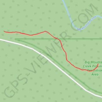
Big Mountain Creek
Big Mountain Creek Provincial Recreation Area. #Hiking #Snowshoeing #BigMountain
- Distance: 0.9 mi
- Elevation gain: 144 ft
- Maximum elevation: 2,175 ft
- Elevation loss: 144 ft
- Minimum elevation: 2,028 ft
Interactive trail map
Thank you for supporting this site ❤️
Make a donation
Make a donation
Gear up for your next adventure:
As an Amazon Associate, this site earns from qualifying purchases at no extra cost to you.
Trail profile
- Distance: 0.9 mi
- Elevation gain: 144 ft
- Maximum elevation: 2,175 ft
- Elevation loss: 144 ft
- Minimum elevation: 2,028 ft
Thank you for supporting this site ❤️
Make a donation
Make a donation
Gear up for your next adventure:
As an Amazon Associate, this site earns from qualifying purchases at no extra cost to you.
About this trail
Name: Big Mountain Creek trail, distance, elevation, map, profile, GPS track
Coordinates: 54.89249 -118.70689 54.89466 -118.69798
Thank you for supporting this site ❤️
Make a donation
Make a donation
Gear up for your next adventure:
As an Amazon Associate, this site earns from qualifying purchases at no extra cost to you.