Thank you for supporting this site ❤️
Make a donation
Make a donation
Gear up for your next adventure:
As an Amazon Associate, this site earns from qualifying purchases at no extra cost to you.
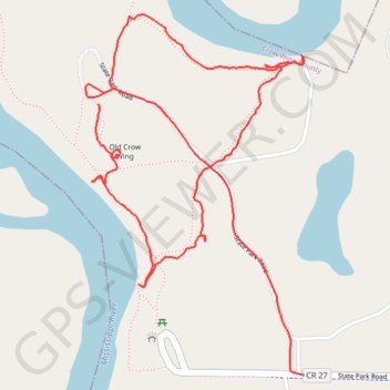
Hiking Crow Wing State Park
- Distance: 2.0 mi
- Elevation gain: 112 ft
- Maximum elevation: 1,198 ft
- Elevation loss: 112 ft
- Minimum elevation: 1,155 ft
- Moving time: 36 m 52 s
- Moving speed: 3.2 mph
- Maximum speed: 15.9 mph
- Total time: 44 m 40 s
- Global speed: 2.7 mph
Interactive trail map
Thank you for supporting this site ❤️
Make a donation
Make a donation
Gear up for your next adventure:
As an Amazon Associate, this site earns from qualifying purchases at no extra cost to you.
Trail profile
- Distance: 2.0 mi
- Elevation gain: 112 ft
- Maximum elevation: 1,198 ft
- Elevation loss: 112 ft
- Minimum elevation: 1,155 ft
- Moving time: 36 m 52 s
- Moving speed: 3.2 mph
- Maximum speed: 15.9 mph
- Total time: 44 m 40 s
- Global speed: 2.7 mph
Thank you for supporting this site ❤️
Make a donation
Make a donation
Gear up for your next adventure:
As an Amazon Associate, this site earns from qualifying purchases at no extra cost to you.
About this trail
Name: Hiking Crow Wing State Park trail, distance, elevation, map, profile, GPS track
Start: State Park Road, Crow Wing County, Minnesota, United States (46.27824 -94.33811)
End: State Park Road, Crow Wing County, Minnesota, United States (46.27275 -94.33208)
Coordinates: 46.27275 -94.33847 46.28005 -94.33208
Topography: Crow Wing County topographic map, elevation, terrain
Thank you for supporting this site ❤️
Make a donation
Make a donation
Gear up for your next adventure:
As an Amazon Associate, this site earns from qualifying purchases at no extra cost to you.