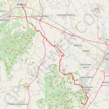
2022_DE_Vicenza-Thermengebiet
- Distance: 31.3 mi
- Elevation gain: 633 ft
- Maximum elevation: 174 ft
- Elevation loss: 761 ft
- Minimum elevation: 13 ft
Interactive trail map
Trail profile
- Distance: 31.3 mi
- Elevation gain: 633 ft
- Maximum elevation: 174 ft
- Elevation loss: 761 ft
- Minimum elevation: 13 ft
About this trail
Name: 2022_DE_Vicenza-Thermengebiet trail, distance, elevation, map, profile, GPS track
End: Via Galzignana, Battaglia Terme, Province of Padua, Veneto, 35041, Italy (45.29274 11.76914)
Coordinates: 45.28826 11.54627 45.54945 11.79632
Other hiking, mountain biking, running and outdoor activity trails
Click on a trail to view its statistics, map and profile.
2022_DE_Thermengebiet-Padua-Mestre
Italy > Veneto > Province of Padua > Galzignano Terme
Distance: 34.6 mi • Elevation gain: 292 ft • Maximum elevation: 69 ft
2022_DE_Verona-Vicenza | flach
Italy > Veneto > Verona > Verona
Distance: 45.5 mi • Elevation gain: 1,545 ft • Maximum elevation: 522 ft