Mary's Rock via Appalachian Trail in Shenandoah National Park
The hike to Mary's Rock via the Appalachian Trail in Shenandoah National Park offers a rewarding ascent through diverse forested landscapes, culminating in expansive vistas of the Blue Ridge Mountains, the Shenandoah Valley the rolling hills of the Piedmont region. Along the route, hikers can observe a variety of flora and fauna, including mountain laurels and boulders, which add to the scenic beauty. The summit provides panoramic views of notable peaks such as Old Rag, Stony Man, and Hawksbill, making the effort worthwhile. #Hiking #Mountain #Forest #Nature
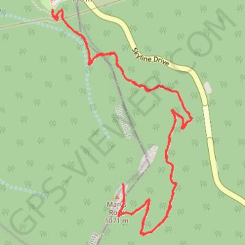
- Distance: 3.8 mi
- Elevation gain: 1,365 ft
- Maximum elevation: 3,425 ft
- Elevation loss: 1,371 ft
- Minimum elevation: 2,326 ft
- Moving time: 1 h 30 m
- Moving speed: 2.5 mph
- Maximum speed: 5.0 mph
- Total time: 1 h 52 m
- Global speed: 2.0 mph
Interactive trail map
Trail profile
- Distance: 3.8 mi
- Elevation gain: 1,365 ft
- Maximum elevation: 3,425 ft
- Elevation loss: 1,371 ft
- Minimum elevation: 2,326 ft
- Moving time: 1 h 30 m
- Moving speed: 2.5 mph
- Maximum speed: 5.0 mph
- Total time: 1 h 52 m
- Global speed: 2.0 mph
About this trail
Name: Mary's Rock via Appalachian Trail in Shenandoah National Park trail, distance, elevation, map, profile, GPS track
Coordinates: 38.64810 -78.32167 38.65918 -78.31288
Topography: Page County topographic map, elevation, terrain
Other hiking, mountain biking, running and outdoor activity trails
Click on a trail to view its statistics, map and profile.
Marys Rock via Appalachian Trail in Shenandoah National Park
United States > Virginia > Page County
Hiking Marys Rock is an exhilarating experience that combines a moderate ascent with breathtaking views at the summit. As you make your way along the well-marked trail, you’ll encounter lush forests and a charming stone chimney, remnants of the past, before reaching the rocky outcrop at the top, where…
Distance: 3.7 mi • Elevation gain: 1,276 ft • Maximum elevation: 3,425 ft