Castle Peak via Castle Valley North Road, Castle Pass and Castle Peak Trail
The route to Castle Peak in Tahoe National Forest offers a scenic and moderate challenge for hikers, with expansive views of the Sierra Nevada's rugged terrain. The trail weaves through a mixture of rocky ridgelines, alpine meadows, and forested paths, revealing picturesque vistas of distant peaks such as Mount Rose and Mount Lassen. From the summit, on clear days, hikers are treated to sweeping panoramas extending as far as the Bay Area's Mount Diablo to the west, and the Lake Tahoe region to the southeast. #Hiking #Mountain #Forest #Nature #Overlook
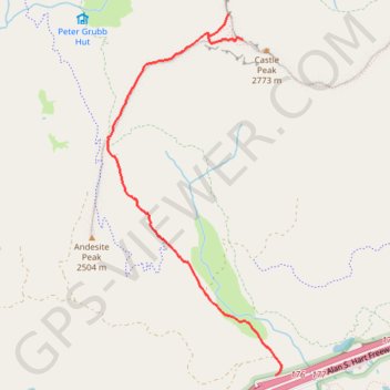
- Distance: 5.9 mi
- Elevation gain: 1,900 ft
- Maximum elevation: 8,986 ft
- Elevation loss: 1,906 ft
- Minimum elevation: 7,254 ft
Interactive trail map
Trail profile
- Distance: 5.9 mi
- Elevation gain: 1,900 ft
- Maximum elevation: 8,986 ft
- Elevation loss: 1,906 ft
- Minimum elevation: 7,254 ft
About this trail
Name: Castle Peak via Castle Valley North Road, Castle Pass and Castle Peak Trail trail, distance, elevation, map, profile, GPS track
Start: Castle Peak Road, Nevada County, California, 95724, United States (39.34039 -120.34803)
End: Castle Peak Road, Nevada County, California, 95724, United States (39.34034 -120.34819)
Coordinates: 39.34034 -120.36496 39.36818 -120.34761
Topography: Nevada County topographic map, elevation, terrain
Other hiking, mountain biking, running and outdoor activity trails
Click on a trail to view its statistics, map and profile.
Andesite Peak Loop via Castle Valley North Road and Hole in the Ground
United States > California > Nevada County
The Andesite Peak Loop in the Tahoe National Forest, is a diverse and rewarding hike. Along the way, you'll traverse through lush meadows, ascend rocky ridgelines, and enjoy sweeping views of surrounding peaks like Castle Peak, with its volcanic features from ancient eruptions. The route provides an…
Distance: 4.8 mi • Elevation gain: 915 ft • Maximum elevation: 8,064 ft