Make a donation
Gear up for your next adventure:
As an Amazon Associate, this site earns from qualifying purchases at no extra cost to you.
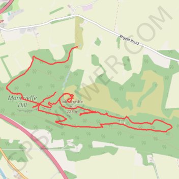
Walking on Moncrieff Hill near Perth
- Distance: 5.0 mi
- Elevation gain: 751 ft
- Maximum elevation: 719 ft
- Elevation loss: 1,010 ft
- Minimum elevation: 318 ft
- Moving time: 1 h 50 m
- Moving speed: 2.7 mph
- Maximum speed: 17.0 mph
- Total time: 2 h 7 m
- Global speed: 2.3 mph
Interactive trail map
Make a donation
Gear up for your next adventure:
As an Amazon Associate, this site earns from qualifying purchases at no extra cost to you.
Trail profile
- Distance: 5.0 mi
- Elevation gain: 751 ft
- Maximum elevation: 719 ft
- Elevation loss: 1,010 ft
- Minimum elevation: 318 ft
- Moving time: 1 h 50 m
- Moving speed: 2.7 mph
- Maximum speed: 17.0 mph
- Total time: 2 h 7 m
- Global speed: 2.3 mph
Make a donation
Gear up for your next adventure:
As an Amazon Associate, this site earns from qualifying purchases at no extra cost to you.
About this trail
Name: Walking on Moncrieff Hill near Perth trail, distance, elevation, map, profile, GPS track
End: Rhynd Road, Rhynd, Perth, Perth and Kinross, Scotland, PH2 8QH, United Kingdom (56.37030 -3.39843)
Coordinates: 56.36043 -3.41329 56.37030 -3.37861
Make a donation
Gear up for your next adventure:
As an Amazon Associate, this site earns from qualifying purchases at no extra cost to you.
Other hiking, mountain biking, running and outdoor activity trails
Click on a trail to view its statistics, map and profile.
Moncrieffe Hill
United Kingdom > Scotland > Perth and Kinross > Perth > Rhynd
eMTB Gravel: Tay Car Park -> Moredun Top Hillfort - Loop (Geocaching) #UK #Perthshire #Perth #Bike #Nature #Forest #Countryside
Distance: 4.8 mi • Elevation gain: 732 ft • Maximum elevation: 719 ft