
Crescent Glacier via South Climb Trail in Gifford Pinchot National Forest
The South Climb Trail leading to Crescent Glacier offers a dynamic journey through diverse terrains, starting with lush forested sections and transitioning to rocky alpine landscapes. Along the way, hikers can enjoy views of wildflower meadows, and as they approach the glacier, expansive snowfields open up with stunning vistas of neighboring peaks like Mount St. Helens and Mount Hood. This route is a favorite for those seeking both scenic beauty and a gateway to higher elevations, such as the popular Lunch Counter campsite and the summit of Mount Adams. #Hiking #Mountain #Forest #Nature #Glacier
- Distance: 6.6 mi
- Elevation gain: 2,789 ft
- Maximum elevation: 8,438 ft
- Elevation loss: 2,874 ft
- Minimum elevation: 5,561 ft
Interactive trail map
Trail profile
- Distance: 6.6 mi
- Elevation gain: 2,789 ft
- Maximum elevation: 8,438 ft
- Elevation loss: 2,874 ft
- Minimum elevation: 5,561 ft
About this trail
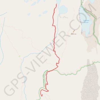
Name: Crescent Glacier via South Climb Trail in Gifford Pinchot National Forest trail, distance, elevation, map, profile, GPS track
Start: South Climb Trail, Yakima County, Washington, United States (46.13756 -121.49579)
End: Cold Springs Campground Road, Yakima County, Washington, United States (46.13635 -121.49761)
Coordinates: 46.13563 -121.49861 46.17088 -121.48822
Topography: Yakima County topographic map, elevation, terrain
Other hiking, mountain biking, running and outdoor activity trails
Click on a trail to view its statistics, map and profile.
Northern part of the Pacific Crest Trail (PCT)
United States > Oregon > Klamath County
Hike on the Pacific Crest National Scenic Trail from Crater Lake to Canada Border through Oregon and Washington along the Sierra Nevada and Cascade mountain ranges. #Hiking #Mountain #SierraNevada #Cascade #Nature #Forest #Park #PCT
Distance: 744.6 mi • Elevation gain: 145,367 ft • Maximum elevation: 7,569 ft