Make a donation
Gear up for your next adventure:
As an Amazon Associate, this site earns from qualifying purchases at no extra cost to you.
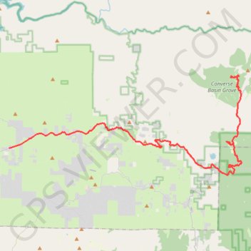
Sequoia National Park - Converse Basin Grove
Giant Sequoia National Monument
- Distance: 33.1 mi
- Elevation gain: 6,417 ft
- Maximum elevation: 6,873 ft
- Elevation loss: 2,129 ft
- Minimum elevation: 1,414 ft
- Moving time: 1 h 17 m
- Moving speed: 25.5 mph
- Maximum speed: 51.8 mph
- Total time: 3 h 43 m
- Global speed: 8.9 mph
Interactive trail map
Make a donation
Gear up for your next adventure:
As an Amazon Associate, this site earns from qualifying purchases at no extra cost to you.
Trail profile
- Distance: 33.1 mi
- Elevation gain: 6,417 ft
- Maximum elevation: 6,873 ft
- Elevation loss: 2,129 ft
- Minimum elevation: 1,414 ft
- Moving time: 1 h 17 m
- Moving speed: 25.5 mph
- Maximum speed: 51.8 mph
- Total time: 3 h 43 m
- Global speed: 8.9 mph
Make a donation
Gear up for your next adventure:
As an Amazon Associate, this site earns from qualifying purchases at no extra cost to you.
About this trail
Name: Sequoia National Park - Converse Basin Grove trail, distance, elevation, map, profile, GPS track
End: Converse Mill Road, Fresno County, California, United States (36.81122 -118.96758)
Coordinates: 36.71297 -119.24807 36.81360 -118.95490
Topography: Fresno County topographic map, elevation, terrain
Make a donation
Gear up for your next adventure:
As an Amazon Associate, this site earns from qualifying purchases at no extra cost to you.
Other hiking, mountain biking, running and outdoor activity trails
Click on a trail to view its statistics, map and profile.
Grant Grove Village to Sequoia Lake Loop
United States > California > Tulare County > Grant Grove Village
Loop hike from Grant Grove Village to Sequoia Lake via Sunset Trail, Ella Falls, Dead Giant Loop Trail, Sequoia Lake Overlook, North Grove Trail, Centennial Stump, General Grant Tree, Tennessee Tree, Michigan Tree and South Boundary Trail in the Kings Canyon National Park and the Giant Sequoia National Forest.…
Distance: 10.9 mi • Elevation gain: 2,110 ft • Maximum elevation: 6,637 ft
Sequoia Big Stump Trail
United States > California > Tulare County
Distance: 2.5 mi • Elevation gain: 397 ft • Maximum elevation: 6,371 ft