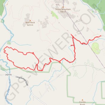
Stone Mountain - Big Sandy Creek
Running
- Distance: 9.1 mi
- Elevation gain: 1,329 ft
- Maximum elevation: 1,873 ft
- Elevation loss: 1,325 ft
- Minimum elevation: 1,302 ft
- Moving time: 2 h 4 m
- Moving speed: 4.4 mph
- Maximum speed: 10.2 mph
- Total time: 2 h 14 m
- Global speed: 4.1 mph
Interactive trail map
Trail profile
- Distance: 9.1 mi
- Elevation gain: 1,329 ft
- Maximum elevation: 1,873 ft
- Elevation loss: 1,325 ft
- Minimum elevation: 1,302 ft
- Moving time: 2 h 4 m
- Moving speed: 4.4 mph
- Maximum speed: 10.2 mph
- Total time: 2 h 14 m
- Global speed: 4.1 mph
About this trail
Name: Stone Mountain - Big Sandy Creek trail, distance, elevation, map, profile, GPS track
Start: Connector Trail, Alleghany County, North Carolina, 28668, United States (36.38388 -81.02809)
End: Connector Trail, Alleghany County, North Carolina, 28668, United States (36.38395 -81.02801)
Coordinates: 36.37214 -81.06864 36.38452 -81.02801
Topography: Alleghany County topographic map, elevation, terrain