Thank you for supporting this site ❤️
Make a donation
Make a donation
Gear up for your next adventure:
As an Amazon Associate, this site earns from qualifying purchases at no extra cost to you.
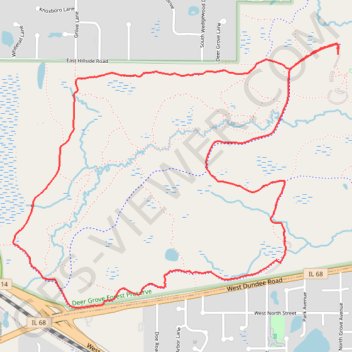
Deer Grove Forest Preserve loop
Cook County Walking
- Distance: 4.3 mi
- Elevation gain: 151 ft
- Maximum elevation: 889 ft
- Elevation loss: 154 ft
- Minimum elevation: 814 ft
- Moving time: 1 h 19 m
- Moving speed: 3.2 mph
- Maximum speed: 4.0 mph
- Total time: 1 h 20 m
- Global speed: 3.2 mph
Interactive trail map
Thank you for supporting this site ❤️
Make a donation
Make a donation
Gear up for your next adventure:
As an Amazon Associate, this site earns from qualifying purchases at no extra cost to you.
Trail profile
- Distance: 4.3 mi
- Elevation gain: 151 ft
- Maximum elevation: 889 ft
- Elevation loss: 154 ft
- Minimum elevation: 814 ft
- Moving time: 1 h 19 m
- Moving speed: 3.2 mph
- Maximum speed: 4.0 mph
- Total time: 1 h 20 m
- Global speed: 3.2 mph
Thank you for supporting this site ❤️
Make a donation
Make a donation
Gear up for your next adventure:
As an Amazon Associate, this site earns from qualifying purchases at no extra cost to you.
About this trail
Name: Deer Grove Forest Preserve loop trail, distance, elevation, map, profile, GPS track
Coordinates: 42.13422 -88.09639 42.14758 -88.07417
Topography: Cook County topographic map, elevation, terrain
Thank you for supporting this site ❤️
Make a donation
Make a donation
Gear up for your next adventure:
As an Amazon Associate, this site earns from qualifying purchases at no extra cost to you.