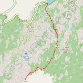
Clouds Rest from Tenaya Lake
From the Sunrise Lakes Trailhead beside Tenaya Lake, the route leaves Tioga Road and moves quickly from the open lakeshore into lodgepole forest and granite slabs, following the southbound trail signed for Clouds Rest and Sunrise before climbing away from the basin above Tenaya Creek.
Beyond the Sunrise Lakes junction, the hike continues toward Clouds Rest, crossing a quieter high-country landscape of open forest, polished granite, small seasonal waters, and broad views back toward the Tenaya Lake area and the surrounding domes.
The final approach reaches the long granite crest of Clouds Rest, where the trail becomes more exposed before opening onto one of Yosemite’s great viewpoints, with Tenaya Canyon below, Half Dome ahead, Yosemite Valley beyond it, and the High Sierra spread out around the summit.
#Hiking #Mountain #Lake #Forest #Nature #Yosemite
- Distance: 12.0 mi
- Elevation gain: 2,890 ft
- Maximum elevation: 9,813 ft
- Elevation loss: 2,890 ft
- Minimum elevation: 8,159 ft
Interactive trail map
Trail profile
- Distance: 12.0 mi
- Elevation gain: 2,890 ft
- Maximum elevation: 9,813 ft
- Elevation loss: 2,890 ft
- Minimum elevation: 8,159 ft
About this trail
Name: Clouds Rest from Tenaya Lake trail, distance, elevation, map, profile, GPS track
Coordinates: 37.76744 -119.48960 37.82584 -119.45775
Topography: Mariposa County topographic map, elevation, terrain
Other hiking, mountain biking, running and outdoor activity trails
Click on a trail to view its statistics, map and profile.
Clouds Rest Trail in Yosemite National Park
United States > California > Mariposa County
The Clouds Rest Trail in Yosemite offers hikers a rewarding, strenuous challenge with breathtaking views throughout. As you ascend, the landscape transforms from lush forest to open granite ridgelines, with expansive vistas of Tenaya Lake and the iconic Half Dome in the distance. The final approach to the…
Distance: 12.6 mi • Elevation gain: 2,864 ft • Maximum elevation: 9,813 ft
Hike from Tenaya Lake to Olmsted Point
United States > California > Mariposa County
Distance: 4.9 mi • Elevation gain: 404 ft • Maximum elevation: 8,432 ft