Mount Remarkable North Face
Morning Mountain Bike Ride
- Distance: 29.0 mi
- Elevation gain: 4,495 ft
- Maximum elevation: 2,762 ft
- Elevation loss: 4,508 ft
- Minimum elevation: 1,007 ft
- Moving time: 11 h 45 m
- Moving speed: 2.5 mph
- Maximum speed: 2.8 mph
- Total time: 11 h 45 m
- Global speed: 2.5 mph
Interactive trail map
Trail profile
- Distance: 29.0 mi
- Elevation gain: 4,495 ft
- Maximum elevation: 2,762 ft
- Elevation loss: 4,508 ft
- Minimum elevation: 1,007 ft
- Moving time: 11 h 45 m
- Moving speed: 2.5 mph
- Maximum speed: 2.8 mph
- Total time: 11 h 45 m
- Global speed: 2.5 mph
About this trail
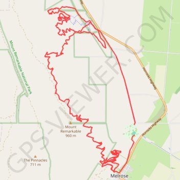
Name: Mount Remarkable North Face trail, distance, elevation, map, profile, GPS track
Coordinates: -32.82568 138.15268 -32.76030 138.19501
Other hiking, mountain biking, running and outdoor activity trails
Click on a trail to view its statistics, map and profile.
Mount Remarkable Epic MTB trail trace
Australia > South Australia > Melrose
2 x Laps of Melrose Epic on the single speed
Distance: 49.6 mi • Elevation gain: 9,777 ft • Maximum elevation: 3,107 ft
Sea to Summit: Spencer Gulf - Flinders Ranges - Melrose
Mount Remarkable National Park. #Hiking #Running #SeaToSummit #Remarkable
Distance: 26.5 mi • Elevation gain: 4,797 ft • Maximum elevation: 3,117 ft