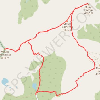
Mounts Democrat, Cameron, Lincoln and Bross from Kite Lake
Interactive trail map
Trail profile
- Distance: 7.2 mi
- Elevation gain: 3,294 ft
- Maximum elevation: 14,252 ft
- Elevation loss: 3,294 ft
- Minimum elevation: 12,021 ft
About this trail
Name: Mounts Democrat, Cameron, Lincoln and Bross from Kite Lake trail, distance, elevation, map, profile, GPS track
Start: County Road 8, Alma, Park County, Colorado, 80420, United States (39.32743 -106.12935)
End: County Road 8, Alma, Park County, Colorado, 80420, United States (39.32743 -106.12935)
Coordinates: 39.32711 -106.13992 39.35152 -106.10917
Topography: Park County topographic map, elevation, terrain