Thank you for supporting this site ❤️
Make a donation
Make a donation
Gear up for your next adventure:
As an Amazon Associate, this site earns from qualifying purchases at no extra cost to you.
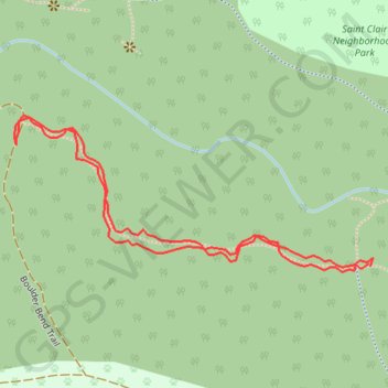
West path Whatcom Falls south
- Distance: 0.6 mi
- Elevation gain: 52 ft
- Maximum elevation: 233 ft
- Elevation loss: 52 ft
- Minimum elevation: 184 ft
- Moving time: 16 m 22 s
- Moving speed: 2.3 mph
- Maximum speed: 3.6 mph
- Total time: 16 m 22 s
- Global speed: 2.3 mph
Interactive trail map
Thank you for supporting this site ❤️
Make a donation
Make a donation
Gear up for your next adventure:
As an Amazon Associate, this site earns from qualifying purchases at no extra cost to you.
Trail profile
- Distance: 0.6 mi
- Elevation gain: 52 ft
- Maximum elevation: 233 ft
- Elevation loss: 52 ft
- Minimum elevation: 184 ft
- Moving time: 16 m 22 s
- Moving speed: 2.3 mph
- Maximum speed: 3.6 mph
- Total time: 16 m 22 s
- Global speed: 2.3 mph
Thank you for supporting this site ❤️
Make a donation
Make a donation
Gear up for your next adventure:
As an Amazon Associate, this site earns from qualifying purchases at no extra cost to you.
About this trail
Name: West path Whatcom Falls south trail, distance, elevation, map, profile, GPS track
Coordinates: 48.75458 -122.44272 48.75592 -122.43806
Topography: Bellingham topographic map, elevation, terrain
Thank you for supporting this site ❤️
Make a donation
Make a donation
Gear up for your next adventure:
As an Amazon Associate, this site earns from qualifying purchases at no extra cost to you.